The LWS (Local Warning System) serves to warn the population against floods, first of all against storm rainfall (e.g. in storms). It consists of several separate measuring stations and a central station.
According to the measured quantity, they are as follows:
• A precipitation measuring station
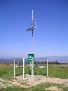
• A water measuring station
The water measuring station measures a water level in a stream in front of a town. A measurement interval is 5 minutes, i.e. a level height in a stream is measured once in 5 minutes and the measured value is compared with four different limits. When any limit is exceeded, the station sends a warning message. A precipitation measuring station measures a rainfall volume. Every 5 minutes, the station evaluates whether the limit was not exceeded. The station evaluates four limits ; summary precipitation for the last 5 minutes, 30 minutes, 60 minutes, 12 hours. If the limit is exceeded, the station sends a warning message.
The central station is usually located at a municipal office. The central station is a computer with WinCentral and SQLView (Visualis) running on it.
The WinCentral communicates with stations, downloads data and limit exceeded warnings from them, checks functionality of the stations; the SQLView presents the measured data. The stations communicate with the central station via GSM, dialled lines or via a radios.